Introduction
Antarctica, Earth’s southernmost continent, remains one of the most mysterious and least-explored regions on the planet. Shaped by extremes in climate and isolated by vast oceans, Antarctica has a unique geography that plays a critical role in the global ecosystem. Often described as the world’s “last frontier,” the continent is a land of ice and snow, stretching across nearly 14 million square kilometers—larger than Europe. This article explores the geographic features that define Antarctica, from its mountain ranges and ice shelves to its deep subglacial lakes.
Section 1: The Layout of the Land
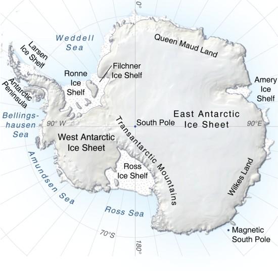
Antarctica’s geography is unlike any other continent. It is covered by the Antarctic Ice Sheet, the largest single mass of ice on Earth, which holds around 60% of the world’s fresh water. Beneath this ice sheet, however, lies a complex and varied landscape of mountains, valleys, and plains. The continent is divided into two main regions:
- East Antarctica: This is the larger and more elevated side of the continent, containing the East Antarctic Ice Sheet, which is thicker and more stable than the ice sheet in the west. The Gamburtsev Mountain Range, buried under the ice, is located here and is thought to be as tall as the Alps, though invisible beneath the ice.
- West Antarctica: This region is geologically active and less stable, contributing to the vulnerability of the West Antarctic Ice Sheet. The landscape here is more fragmented, with islands, peninsulas, and archipelagos. Notably, the Antarctic Peninsula extends northward toward South America and is one of the most rapidly warming areas on Earth.
Section 2: The Antarctic Ice Sheet and Ice Shelves
One of Antarctica’s most striking geographic features is its extensive ice coverage. The Antarctic Ice Sheet extends over nearly the entire continent, with an average thickness of 2,160 meters (around 7,090 feet), and is an ever-changing landscape due to its interaction with climate and oceanic forces.
Ice Shelves
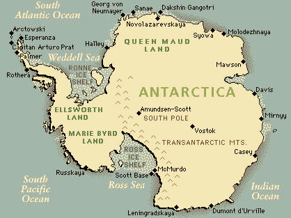
Ice shelves are massive, floating extensions of the ice sheet that protrude over the surrounding ocean. Some of the largest include the Ross Ice Shelf and the Ronne Ice Shelf, each spanning hundreds of thousands of square kilometers. These ice shelves act as buttresses, slowing the flow of glaciers from land into the ocean, a role that’s crucial in regulating global sea levels.
However, as temperatures increase, the stability of these ice shelves is threatened, leading to breakages and the formation of massive icebergs. The collapse of major ice shelves could result in a dramatic rise in sea levels, affecting coastlines worldwide.
Section 3: Mountains and Volcanoes
While it’s known for its icy plains, Antarctica is also home to significant mountain ranges and volcanic features.
- The Transantarctic Mountains: Stretching across the continent, the Transantarctic Mountains act as a natural divider between East and West Antarctica. This range spans approximately 3,500 kilometers (2,175 miles) and features Mount Kirkpatrick, standing at 4,528 meters (14,856 feet) above sea level.
- Ellsworth Mountains: Located in West Antarctica, these mountains contain the continent’s highest peak, Mount Vinson, which rises to 4,892 meters (16,050 feet).
- Active Volcanoes: Antarctica hosts active volcanoes, including Mount Erebus on Ross Island, the southernmost active volcano on Earth. With its persistent lava lake, Mount Erebus has intrigued scientists as it offers insights into geothermal processes in extreme conditions.
Section 4: Hidden Lakes and Rivers Beneath the Ice
One of the most fascinating aspects of Antarctic geography lies not on the surface but deep beneath the ice. Over the past few decades, scientists have discovered a hidden network of subglacial lakes and rivers beneath the ice sheet.
- Lake Vostok: The largest of these lakes, Lake Vostok, is buried under 4 kilometers (2.5 miles) of ice and is thought to have been isolated from the surface for millions of years. The conditions within this lake could potentially harbor unique microbial life, offering a window into life’s resilience in extreme conditions.
- Subglacial Rivers and Aquifers: In addition to lakes, researchers have found subglacial rivers and aquifers that transport water beneath the ice. These waterways impact ice movement, providing lubrication that can accelerate glacial flow and influence sea level rise.
Section 5: Climate and Environmental Challenges
Antarctica’s climate is dominated by extreme cold, with temperatures reaching as low as -89.2°C (-128.6°F) at the Russian Vostok Station, one of the coldest temperatures recorded on Earth. However, Antarctica is not immune to climate change.
Over the past few decades, the Antarctic Peninsula has experienced significant warming, resulting in glacial melt and the loss of ice shelves. The consequences of this warming are not limited to Antarctica; they have global implications. As ice melts, it contributes to sea-level rise and alters ocean currents, impacting weather patterns around the world.
Section 6: Human Exploration and Research Stations
Human presence in Antarctica is restricted to research stations operated by various countries. These stations serve as hubs for scientific research, focusing on everything from geology and glaciology to climate studies. Some key research stations include:
- McMurdo Station (U.S.): Located on Ross Island, this is the largest research station in Antarctica and serves as a logistical hub for many U.S.-led expeditions.
- Vostok Station (Russia): Known for its extreme cold, this station is located near Lake Vostok and has been a key site for studying subglacial conditions.
- Amundsen-Scott South Pole Station: Located at the South Pole, this station is pivotal for studying atmospheric science and astronomy, taking advantage of Antarctica’s unique conditions for clear, stable observations.

Conclusion
Antarctica’s unique geography is a testament to the planet’s extremes and complexity. From massive ice sheets and hidden lakes to active volcanoes, the continent’s features reveal the dynamic forces that shape Earth. While it remains largely uninhabited, Antarctica’s geographic and environmental changes have far-reaching effects on global ecosystems and sea levels, reminding us of the interconnectedness of our planet. As scientists continue to explore and uncover Antarctica’s secrets, the importance of preserving this icy frontier becomes ever clearer for future generations.

